
Anúncios
Rivers speak a language of their own, revealing secrets about terrain, obstacles, and downstream conditions to those who learn to read their visual cues.
🌊 The Hidden Language Rivers Tell
Every paddler, kayaker, or outdoor enthusiast who spends time on flowing water quickly realizes that rivers communicate constantly. The surface patterns, disruptions, and movements aren’t random—they’re a sophisticated code that reveals what lies beneath and what terrain surrounds the waterway. Understanding this river language transforms a simple float into a strategic navigation experience where safety, efficiency, and environmental awareness converge.
Anúncios
Water doesn’t lie. Its behavior on the surface directly reflects the topography below, the obstacles it encounters, and the channel characteristics that shape its journey. From subtle ripples to dramatic standing waves, each feature provides critical information about depth, current speed, underwater structures, and nearby landforms. Mastering this visual vocabulary empowers river travelers to make informed decisions, anticipate challenges, and appreciate the dynamic relationship between water and landscape.
Understanding Flow Patterns and What They Reveal
The most fundamental aspect of river-language navigation involves recognizing flow patterns. Smooth, glassy water typically indicates deep sections with minimal obstructions, while textured surfaces suggest complexity below. Fast-moving water creates V-shaped patterns pointing downstream, with the apex indicating the deepest channel—nature’s highway through rapids and shallow sections.
Anúncios
Conversely, upstream-pointing V-shapes signal obstacles just beneath the surface. Rocks, logs, or sandbar formations create these distinctive patterns as water flows around them and rejoins on the downstream side. The width and definition of these patterns provide clues about obstacle size and depth below the surface.
Reading Current Speed Through Surface Characteristics
Current velocity leaves unmistakable signatures on the water’s surface. Fast currents create standing waves, boils, and turbulent patches where different speeds collide. Slow-moving water appears darker and smoother, often accumulating foam, leaves, and other floating materials that mark lazy current lines.
The gradient change between fast and slow water creates seam lines—visible boundaries that experienced navigators use to identify transition zones. These seams often mark the edges of the main channel, drop-offs into deeper pools, or the boundaries of hydraulic features that require careful approach.
🔄 Decoding Eddies: Nature’s Rest Stops and Information Centers
Eddies represent one of the most important features in river-language literacy. These circular currents form behind obstacles where water flows upstream to fill the void created by the obstruction. Eddies serve as natural parking spots for paddlers, but they also provide crucial topographic information.
The size and strength of an eddy correlates directly with the obstacle that created it and the current speed. Large, powerful eddies indicate substantial obstructions—often rocks, boulders, or shoreline protrusions significant enough to create recreational hazards or navigation challenges. Small, weak eddies might form behind minor features or in slower current sections.
Eddy Lines as Topographic Indicators
The boundary between an eddy and the main current—the eddy line—reveals important details about river structure. Sharp, well-defined eddy lines suggest strong current differentials and pronounced obstacles. These lines often mark steep drop-offs, large boulders, or significant channel constrictions that accelerate flow.
Diffuse eddy lines indicate gentler topography, smaller obstacles, or slower overall current. The angle at which the eddy line extends downstream provides information about current speed—the more downstream it extends, the faster the main current compared to the eddy’s reverse flow.
Strategic Eddy Reading for Navigation
Experienced river navigators use eddies as stepping stones through complex sections. The pattern of eddies reveals the sequence of obstacles and the path of deepest water. A series of eddies on river right suggests a boulder garden or rocky shoreline, while the absence of eddies on river left might indicate an open channel or deeper water along that bank.
Eddies also accumulate debris, creating visual markers for persistent features. An eddy consistently filled with foam, leaves, or wood indicates a stable obstacle that will remain in place across varying water levels—valuable information for route planning on familiar rivers.
🌿 Debris Patterns: Reading Nature’s Breadcrumbs
Floating and stranded debris provides a wealth of topographic information for those who understand what they’re seeing. Foam lines, leaf accumulations, and floating wood don’t distribute randomly—they follow current patterns and collect in specific zones that reveal underlying river structure.
Foam naturally accumulates along seam lines, in eddies, and in slower-moving sections. By observing foam distribution, navigators can identify the main channel boundaries, locate back eddies behind obstacles, and spot hydraulic features where aerated water creates persistent foam patches.
Stranded Debris as Elevation Markers
Debris caught in streamside vegetation, perched on rocks, or lodged against obstacles tells the story of recent water levels. High-water marks indicated by stranded leaves, grass, and twigs show maximum recent flows, helping navigators understand seasonal variations and current conditions relative to the river’s range.
Fresh debris hung in trees or bushes several feet above current water level indicates recent flooding or dam releases. This information proves critical for assessing potential hazards, understanding current strength relative to normal conditions, and anticipating how features might change if water levels rise again.
Log Jams and Sweepers: Hazard Identification
Accumulated wood debris creates some of the most dangerous river hazards, but the patterns of wood accumulation also reveal important topographic details. Log jams typically form where current slows—behind islands, in side channels, or at the upstream end of gravel bars. These accumulations mark slower-water zones and secondary channels.
Sweepers—trees that have fallen into the river but remain attached to the bank—indicate outside bends where erosion undermines shoreline vegetation. The presence of multiple sweepers along a bank reveals the river’s active erosion zone and suggests deeper water along that shore as the current cuts into the bank.
💧 Surface Boils and Upwellings: Windows to the River Bottom
Boils represent one of the most informative yet often misunderstood river features. These mushroom-shaped upwellings of water occur where current flowing along the bottom encounters obstacles and is forced upward to the surface. The resulting circular, bubbling disturbance reveals the presence of large underwater features—typically boulders, bedrock ledges, or significant depth changes.
Strong boils indicate powerful underwater currents and substantial depth. They commonly appear downstream of drops, in deep pools below rapids, and where constricted channels suddenly widen. The spinning, unpredictable nature of boils can challenge boat control, but they also mark the deepest sections of pools—information valuable for navigation and understanding channel structure.
Interpreting Boil Patterns
Random, scattered boils suggest an irregular bottom with numerous obstacles—characteristic of boulder-strewn sections or bedrock rivers with complex underwater topography. Linear patterns of boils often indicate underwater ledges, the edges of deep channels, or the downstream side of significant drops where water plunges and then rebounds toward the surface.
The timing and consistency of boils also provides information. Persistent boils that remain in fixed locations mark permanent features, while intermittent boils that appear and disappear suggest dynamic hydraulics influenced by subtle flow variations.
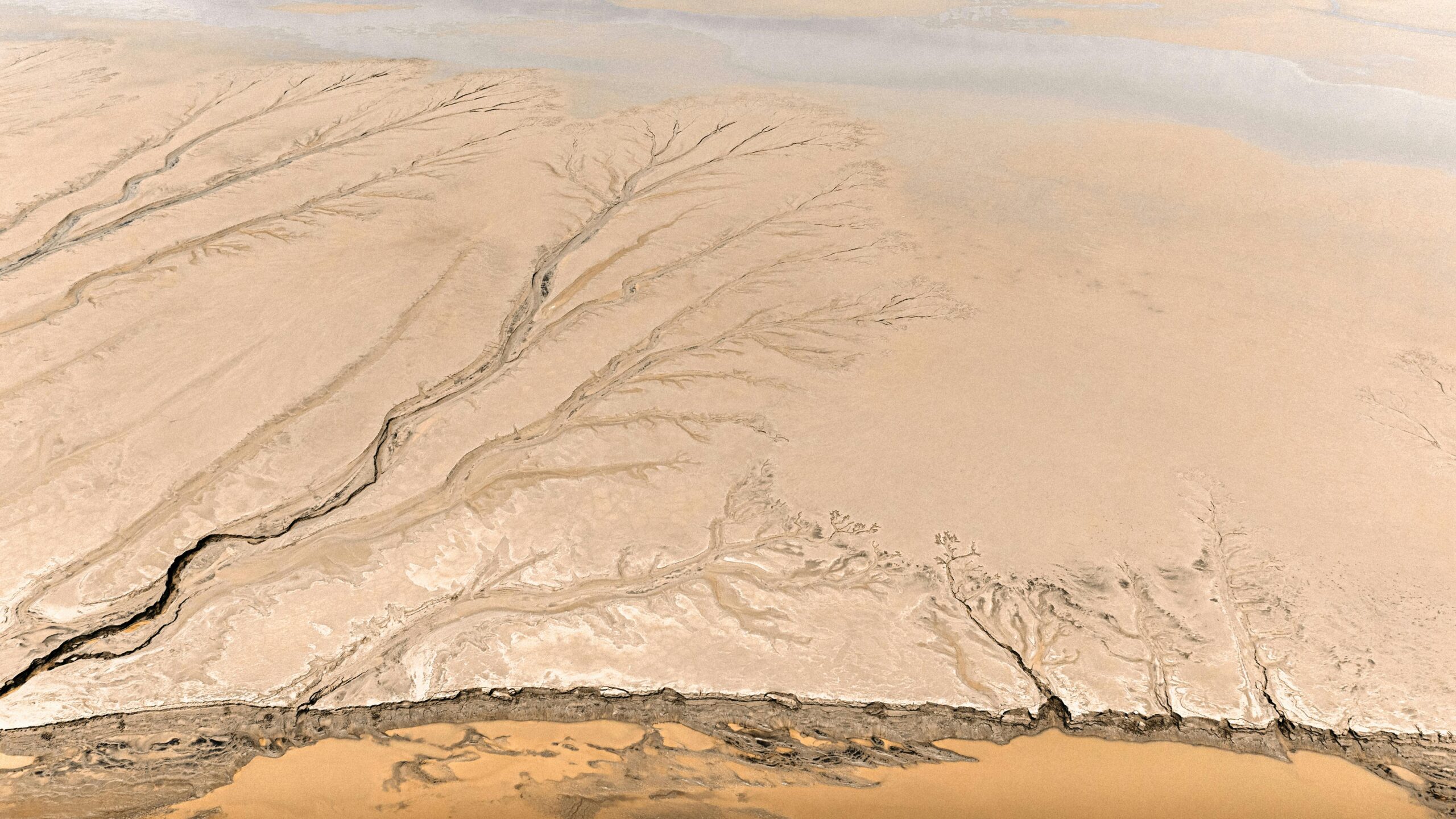
🏔️ Connecting Surface Features to Surrounding Topography
River language extends beyond the water itself to reveal characteristics of the surrounding landscape. The relationship between river behavior and adjacent terrain creates patterns that knowledgeable observers use to understand both immediate conditions and broader geographic context.
Rivers flowing through narrow canyons or confined valleys typically exhibit faster currents, more turbulent water, and fewer large eddies due to increased gradient and channelization. The constricted nature of the landscape forces water through a smaller space, accelerating flow and creating more dramatic surface features.
Valley Width and River Behavior
In contrast, rivers meandering through wide valleys or flat terrain display gentler characteristics—slower currents, more pronounced meanders, and extensive gravel bars. The surface language becomes subtler, with smaller features that require closer observation to decode.
The transition zones between these environments create particularly interesting reading opportunities. Where a river exits a canyon into a valley, the sudden decrease in gradient and increase in channel width causes dramatic changes in flow patterns. Current slows, sediment drops out to form bars and islands, and the character of the river transforms within a short distance—all visible through careful observation of surface patterns.
Tributary Junctions and Sediment Signals
Where tributaries join the main river, distinct patterns emerge. Sediment-laden tributary water often creates visible color differences—a muddy stream entering a clear river, or vice versa. The mixing zone reveals current dynamics as the two flows integrate, with swirls and boils marking the confluence.
The size and behavior of this mixing zone indicates relative flow volumes and velocities. A small tributary barely disturbs a large river, creating minimal surface disruption. An equally sized tributary creates extensive turbulence as the two flows compete for dominance, often producing standing waves, complex eddies, and unpredictable currents that extend downstream for considerable distances.
⚠️ Hydraulics: Recognizing Dangerous Features
Certain surface patterns indicate hydraulic features that pose serious hazards. Recognizing these danger signals represents perhaps the most critical aspect of river-language navigation, as misreading these signs can have severe consequences.
Holes or hydraulics form where water flows over a drop and curls back upstream, creating a retentive feature that can trap boats and swimmers. The surface signature includes an upstream-flowing foam pile, often with a defined line separating the recirculating water from the downstream current. The darkness of the water in the trough and the height of the foam pile indicate the hydraulic’s power.
Distinguishing Safe from Dangerous Features
Not all holes pose equal danger. Wave holes—created by underwater ledges or rocks—tend to be less retentive and often have clear exit routes at the edges. River-wide hydraulics formed by low-head dams or uniform ledges present extreme danger due to their uniform, retentive nature across the entire channel width.
The key distinction lies in the pattern of water exiting the feature. Holes with strong downstream current at the edges and visible escape routes signal navigable features. Uniform foam piles extending across the entire river with no visible downstream flow indicate deadly hydraulics that should be portaged without exception.
🎯 Practical Application: Putting It All Together
Mastering river language requires integrating multiple information sources into a comprehensive understanding of current conditions and upcoming features. Successful navigation involves constantly scanning ahead, identifying patterns, forming hypotheses about what lies beneath and around the next bend, and adjusting plans based on observed evidence.
The process becomes intuitive with practice. Experienced river travelers unconsciously process dozens of visual cues simultaneously—the texture of water approaching a rapid, the pattern of eddies along a shore, the distribution of foam and debris, the sound of water ahead, and the relationship between these features and the visible landscape.
Developing Your River Reading Skills
Begin by focusing on individual features in safe conditions. Observe an eddy closely—note its size, the sharpness of the eddy line, and what debris accumulates there. Then investigate what created it. This direct correlation between surface pattern and underlying cause builds the pattern recognition essential for accurate reading.
Progress to reading sequences of features. In a rapid, identify the main channel by following the downstream-pointing V’s. Note where eddies form and what that suggests about obstacle placement. Observe how current speed changes, where transitions occur, and how these relate to the channel’s shape and gradient.
Seasonal and Flow-Level Variations
Understanding how river language changes with water level adds another dimension to navigation literacy. Features prominent at low water may disappear at high flows, while new patterns emerge. A boulder creating a significant eddy at medium flows might be fully submerged during floods, replaced by a large boil as water rushes over the top.
This variation means river reading requires constant observation and adjustment. The same river reach demands different reading and different navigation strategies across the seasonal flow range. Developing this adaptive understanding separates truly skilled river navigators from those who’ve merely memorized one set of conditions.
🗺️ Topographic Insights Beyond Navigation
The skills developed through river-language navigation extend beyond immediate travel decisions. Understanding flow patterns provides insights into geomorphology, ecology, and the dynamic processes shaping landscapes.
Erosion patterns visible through vegetation loss, cut banks, and debris accumulation reveal how rivers migrate across valleys, cutting new channels and abandoning old ones. These observations connect to broader understanding of watershed dynamics, sediment transport, and long-term landscape evolution.
Wildlife habitat preferences correlate with specific river features. Fish hold in eddies and seams where food concentrates and energy expenditure minimizes. Birds nest near stable gravel bars. Aquatic insects thrive in specific current speeds and substrate types. Reading the river reveals these ecological relationships, enriching the experience beyond simple navigation.
🚣 The Continuous Learning Journey
River language fluency develops over a lifetime of observation and experience. Each river speaks with a unique accent reflecting its geology, gradient, and character. Canyon streams tumbling over bedrock communicate differently than valley rivers meandering through sediment. High-volume glacier-fed torrents present distinct patterns compared to gentle spring creeks.
This diversity means learning never stops. Every new river, every different flow level, every seasonal variation adds to your vocabulary and deepens comprehension. The most experienced river travelers remain perpetual students, recognizing that water always has more to teach those willing to observe carefully and think critically about what they’re seeing.
The rewards of this learning extend far beyond practical navigation benefits. Understanding river language connects you more deeply to the natural world, revealing the elegant logic governing how water shapes landscapes and creates the features we find so compelling. This knowledge transforms every river journey into a conversation with the water, a dialogue where careful observation and thoughtful interpretation unlock insights invisible to untrained eyes.
Whether you’re a kayaker scouting rapids, an angler reading currents to place your fly, a hiker crossing backcountry streams, or simply someone who appreciates the beauty and power of flowing water, developing river-language literacy enriches your experience and deepens your connection to these dynamic environments. The investment in learning this language pays dividends in safety, success, and profound appreciation for the intricate patterns that define river systems and the landscapes they create.