
Anúncios
Finding the perfect fishing spot has never been easier thanks to modern mobile apps designed specifically for anglers who want to explore new waters and maximize their catch success.
Whether you’re a seasoned angler or just starting your fishing journey, having access to detailed location data, weather conditions, and community-shared hotspots can transform your experience on the water. These specialized applications combine GPS technology, real-time data, and social features to help you discover productive fishing areas near you or plan adventures in unfamiliar territories.
Anúncios
Gone are the days of relying solely on word-of-mouth tips or spending hours scouting locations without any guarantee of success. Modern fishing apps provide comprehensive information at your fingertips, allowing you to make informed decisions before you even leave home. From depth charts to species distribution maps, these digital tools have revolutionized how anglers approach their favorite pastime.
🎣 Why Modern Anglers Need Location-Based Fishing Apps
The fishing landscape has evolved dramatically over the past decade. Traditional methods of finding productive waters—asking locals, studying paper maps, or simply trying your luck—still have their place, but technology has opened up entirely new possibilities for discovering prime fishing locations.
Anúncios


Mobile fishing apps aggregate data from multiple sources including satellite imagery, bathymetric surveys, government fish stocking records, and user-generated reports. This creates a comprehensive picture of where fish are likely to be at any given time. The convenience factor alone makes these apps invaluable, but their true power lies in the depth of information they provide.
Time is precious for most anglers, especially those balancing fishing with work and family commitments. A fishing location app helps you maximize every moment on the water by directing you to spots with the highest probability of success based on current conditions, historical data, and recent catches reported by other users.
🗺️ Essential Features to Look for in Fishing Location Apps
Not all fishing apps are created equal. When choosing an application to help you find fishing spots, certain features stand out as particularly valuable for serious anglers.
Interactive Mapping and GPS Navigation
The foundation of any quality fishing location app is its mapping capability. Look for apps that offer detailed, interactive maps with GPS integration that allows you to mark waypoints, save favorite locations, and navigate directly to productive waters. Satellite imagery overlays can help you identify structure, vegetation, and access points before you arrive.
Offline map functionality is especially important if you frequently fish in remote areas with limited cellular coverage. The ability to download maps ahead of time ensures you’ll never be without navigation, regardless of signal strength.
Depth Charts and Bathymetric Data
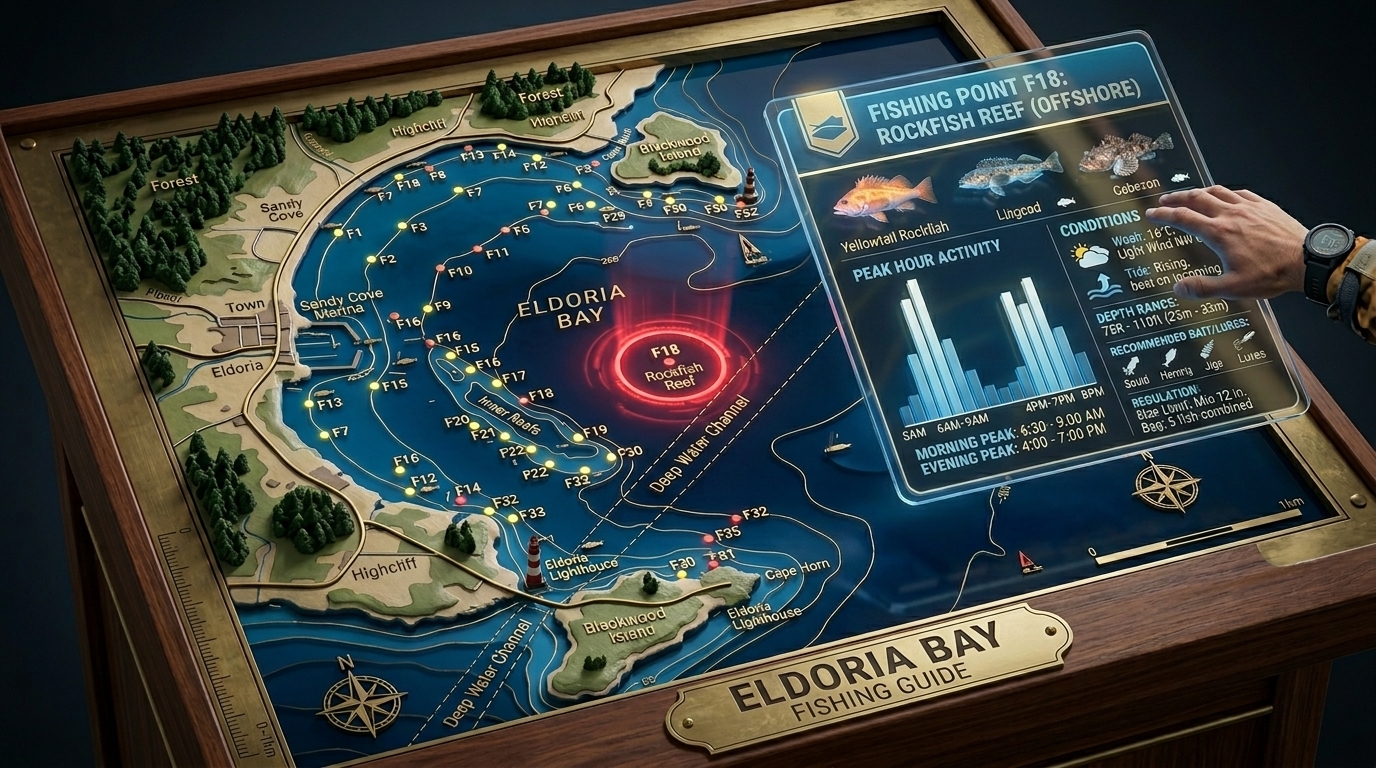
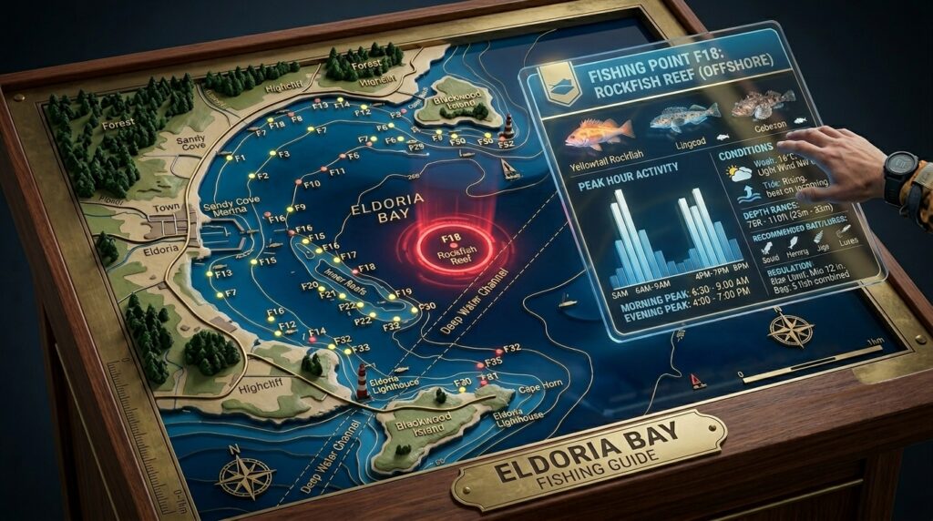
Understanding underwater topography is crucial for locating fish, particularly in larger bodies of water. Quality fishing apps provide detailed depth charts and contour maps that reveal channels, drop-offs, humps, and other underwater features where fish congregate. This information is particularly valuable for boat anglers but can also help shore fishermen identify the best casting locations.
Weather and Water Condition Forecasts
Fish behavior is heavily influenced by environmental conditions. The best fishing apps integrate comprehensive weather forecasts including wind speed and direction, barometric pressure, moon phases, and solunar tables. Water temperature data, clarity reports, and flow rates for rivers and streams provide additional insights into fish activity levels and feeding patterns.
Community Reports and Catch Logs
Social features that allow anglers to share recent catches, effective techniques, and current conditions create tremendous value. Reading reports from other fishermen who’ve recently visited a location gives you up-to-the-minute intelligence that static data simply cannot provide. Look for apps with active user communities and recent posting activity in your area.

📱 How Fishing Location Apps Work Behind the Scenes
Understanding the technology behind these applications helps you appreciate their capabilities and limitations. Most fishing apps combine multiple data sources and technologies to deliver their location-finding features.
GPS satellites provide precise positioning data that allows the app to show your exact location on the map and calculate distances to fishing spots. When you mark a waypoint or save a favorite location, these coordinates are stored in the app’s database for future reference.
Many apps partner with marine electronics companies or government agencies to access bathymetric survey data. This information, originally collected for navigation safety or scientific research, is repurposed to help anglers understand underwater terrain. Satellite imagery from sources like Google Maps or specialized providers offers visual context for fishing locations.
The social components of fishing apps rely on cloud databases that store user-submitted reports, photos, and catch data. When someone logs a catch or posts a report, that information becomes available to other users in real-time or near-real-time, creating a constantly updating knowledge base.
🌊 Types of Waters You Can Explore with Fishing Apps
One of the greatest advantages of comprehensive fishing location apps is their coverage across different types of water bodies. Whether you prefer freshwater or saltwater fishing, there’s likely extensive data available for your preferred environment.
Lakes and Reservoirs
Lake fishing apps typically offer detailed contour maps showing depths, underwater structure, and known fishing hotspots. Many include information about boat ramps, parking areas, and shoreline access points. For large reservoirs, apps may show submerged roads, old creek channels, and flooded timber—all prime fish-holding structure.
Rivers and Streams
River fishing apps focus on features like current speed, access points, rapids, pools, and seasonal migration routes for species like salmon and steelhead. Flow rate data helps you time your trips for optimal conditions. Some apps highlight public access areas and fishing regulations specific to different river sections.
Coastal and Offshore Waters
Saltwater fishing apps often include tide charts, reef locations, shipping channels, artificial reefs, wrecks, and offshore structure. NOAA charts provide navigation safety information that doubles as fishing intelligence. Real-time sea surface temperature maps help locate thermal breaks where gamefish concentrate.
Ponds and Small Waters
Even small neighborhood ponds and farm ponds appear in many fishing apps, often with user-submitted information about species present, access rules, and productive techniques. These overlooked waters can provide excellent fishing opportunities close to home.
🔍 Finding Hidden Fishing Gems Near You
One of the most exciting aspects of using fishing location apps is discovering productive waters you never knew existed. Many anglers are creatures of habit, returning to the same handful of spots repeatedly. These apps encourage exploration and help you expand your fishing horizons.
Start by using your app’s search or browse features to identify all fishable waters within your desired travel radius. You’ll likely be surprised at how many options exist, including small lakes, public ponds, and river access points you’ve driven past countless times without realizing they held fish.
Pay special attention to recently stocked waters. Many state fish and wildlife agencies regularly stock public waters with catchable-sized fish, and apps often include this stocking data. Timing a visit shortly after a stocking event can result in excellent fishing with minimal effort.
Look for waters with high ratings or numerous positive reports but relatively few overall reviews. These are the hidden gems—productive spots that haven’t been discovered by the masses. Conversely, extremely popular locations with hundreds of reviews may experience significant fishing pressure that reduces catch rates.
⚙️ Maximizing Your Success with App-Based Location Data
Simply having a fishing app doesn’t guarantee success. Learning to interpret the data and apply it effectively separates casual users from those who truly leverage these tools to their advantage.
When researching a new location, cross-reference multiple information sources within the app. Check the depth charts, read recent catch reports, study satellite imagery, and review the weather forecast. This comprehensive approach gives you a complete picture rather than relying on any single data point.
Pay attention to patterns in catch reports. If multiple anglers report success from the same area during similar conditions, you’ve identified a reliable pattern worth replicating. Note the times of day, weather conditions, and techniques that produced results.
Don’t ignore older reports entirely. While recent information is generally more valuable, historical data spanning multiple seasons can reveal long-term patterns. A spot that consistently produces during spring turnover or fall feeding periods is likely to do so again.
Use the navigation features to plan efficient fishing circuits. Rather than fishing randomly, create a systematic approach that allows you to cover multiple promising areas methodically. Mark each spot you fish and log your results to build your personal database of knowledge.
🎯 Combining Traditional Knowledge with Digital Tools
While fishing apps provide tremendous advantages, the most successful anglers blend technology with traditional fieldcraft and experience. Apps should enhance your skills, not replace them entirely.
Use app data to get you in the ballpark, then rely on your observational skills and fishing knowledge to fine-tune your approach. Baitfish activity, bird behavior, water color, and current conditions visible at the location may suggest adjustments to what the app recommends.
Talk to other anglers you encounter on the water. The human connection and real-time conversation often reveal nuances that app reports miss. Most fishermen are happy to share general information, and these interactions build the kind of local knowledge that technology alone cannot provide.
Keep your own detailed logs within the app. The more information you contribute about your catches, techniques, and observations, the more valuable the app becomes—both for you and for the community. Your reports from six months ago might be exactly what you need to remember when conditions repeat themselves.
🌟 Privacy and Conservation Considerations
As fishing apps become more sophisticated and popular, important questions arise about privacy and environmental impact. Responsible use of these tools ensures they remain beneficial for both anglers and fish populations.
Consider carefully what information you share publicly. While community reports are valuable, broadcasting the exact GPS coordinates of a pristine, lightly-fished spot can lead to overcrowding and potentially harm the fishery. Many experienced anglers share general area information without pinpointing their most treasured locations.
Respect private property and posted regulations. Just because an app shows a body of water doesn’t mean you have legal access. Always verify access rights and follow local regulations regarding seasons, limits, and methods.
Practice catch and release for species under pressure, and handle fish carefully regardless of whether you’re keeping them. The fishing spots you discover through apps will only remain productive if anglers act as stewards, not just consumers, of the resource.
📊 Evaluating App Performance and Reliability
With numerous fishing apps available, how do you determine which ones deserve space on your phone and your trust on the water?
Start with user reviews and ratings, but read them critically. Look for comments about accuracy of mapping data, frequency of updates, and quality of community reports in your specific region. An app with a strong user base in Florida may have limited value for anglers in the Pacific Northwest.
Test the app’s offline functionality before relying on it in remote areas. Download maps for your region and ensure all essential features work without cellular connection. Nothing is more frustrating than discovering crucial features require internet access when you’re miles from any signal.
Evaluate the accuracy of depth charts and satellite imagery by comparing them to your on-water observations. Most apps use quality data sources, but occasional errors occur. If you notice significant discrepancies, report them to the developer and use caution when fishing unfamiliar waters.
Consider the app’s update frequency and developer support. Apps that receive regular updates with new features, bug fixes, and fresh data are more likely to remain useful long-term compared to neglected applications.
🚀 Advanced Features for Serious Anglers
Beyond basic location finding, many fishing apps offer advanced features that appeal to dedicated anglers seeking every possible advantage.
Tournament mode features allow competitive anglers to log catches quickly during events, track their standings, and submit results efficiently. Photo verification and length measurement tools using your phone’s camera add objectivity to catch reporting.
Integration with marine electronics like fish finders and chartplotters creates a seamless ecosystem where data flows between devices. Mark a productive spot on your fish finder, and it automatically appears in your mobile app for future reference.
Species-specific filters help you target particular fish by showing waters where they’re present, recent catches, and seasonal patterns. If you’re specifically targeting bass, walleye, or redfish, these filters eliminate irrelevant information and focus your search.
Trip planning tools allow you to organize multi-day fishing adventures, creating itineraries with multiple destinations, accommodation options, and tackle shop locations. Some apps even calculate drive times and suggest efficient routes between fishing spots.
💡 Tips for New Users Getting Started
If you’re new to fishing location apps, the array of features and data can feel overwhelming. Start with these practical steps to get the most value quickly.
Begin by exploring waters you already know well. Search for your regular fishing spots in the app and see what information appears. This familiarization process in a comfortable environment helps you understand how the app represents different features and how accurate its data is for your area.
Spend time browsing the map in your region without any specific destination in mind. You’ll discover nearby waters you never knew existed and begin building a mental map of fishing opportunities around you.
Read the app’s tutorial or help section to understand all available features. Many powerful tools remain hidden in menus that new users never explore. Five minutes reading documentation can save hours of trial and error.
Start logging your own catches and experiences immediately. Even if you don’t plan to share them publicly, personal logs create a valuable reference that improves with every fishing trip. Over time, patterns emerge that guide your future decisions.
🌐 The Future of Fishing Location Technology
Fishing apps continue evolving rapidly as new technologies emerge and developers find innovative ways to serve anglers’ needs.
Artificial intelligence and machine learning algorithms are beginning to analyze vast amounts of fishing data to predict optimal times and locations with unprecedented accuracy. These systems learn from thousands of catches and environmental variables to suggest when and where you should fish for the best results.
Augmented reality features may soon overlay fishing information directly onto your phone’s camera view, showing depth contours, structure locations, and fishing tips as you scan the water in front of you.
Improved satellite technology and remote sensing provide ever more detailed information about water conditions, vegetation, and even fish concentrations from space. As this data becomes more accessible, fishing apps will offer increasingly precise location recommendations.
Social features will likely expand beyond simple catch reports to include live video streams, virtual fishing guides, and community-based tournaments that connect anglers worldwide while highlighting local fishing opportunities.
The integration of fishing apps with smart home devices, voice assistants, and wearable technology will make accessing fishing information more seamless than ever. Imagine asking your smart speaker for fishing conditions at your favorite lake while you’re making breakfast, or receiving notifications on your smartwatch when conditions become ideal at saved locations.
As these applications continue improving, they’ll become even more indispensable tools for anglers of all skill levels, making the ancient pursuit of fishing more accessible, successful, and enjoyable than ever before. The key is embracing these technological aids while maintaining respect for the traditions, ethics, and conservation principles that ensure healthy fisheries for future generations. Whether you’re a weekend warrior or a dedicated tournament angler, fishing location apps represent a powerful ally in your quest for that next memorable catch. 🎣